This article [2nd of two parts (part 1)] analyses the development context and outcome of Cambodia’s largest and most costly irrigation scheme, based on a visit to the eastern provinces of Prey Veng and Kampong Cham just prior to the late July general elections. It found that the project, built under a US$200 million loan from China, has failed to irrigate a single hectare of land after several years of operation. Without an evaluation of the reasons for the first failed phase, the Cambodian state is now embarking on a new, more expensive phase of development.
Although media reports are awash with stories of environmentally and socially damaging hydropower projects popping up across the Mekong region, it is curious to ponder why irrigation projects have not attracted a similar level of critical attention. After all they also block rivers with walls of concrete, divert water flows across basins and landscapes, lead to the addition of vast amounts of agrichemicals to the environment, and other impacts besides, yet there have been no systematic regional studies to date beyond the 2000 World Commission on Dams report, which found that irrigation dams in Asia generally performed poorly against industry set targets.
With hydropower projects targets mostly focus on the megawatts of installed capacity or gigawatt hours of electricity generated, and in nearly all cases the projects end up producing at least some power; whereas with irrigation schemes they are generally measured by a target area of land to be supplied with water (known as the “command area”), with the number of beneficiaries a secondary concern, whether households or individuals. Yet perhaps surprisingly, in the bulk of cases irrigation projects in the region end up supplying just a fraction of their intended command area, especially in the dry season, and prove to be highly inefficient in delivering water reliably to farmers who need it. And in a few cases, projects fail to supply any agricultural land with water. The Vaico River Project in eastern Cambodia is a case in point.
Mega-projects, more impacts, less transparency?
This project has an announced command area of some 300,000 hectares, but to date has yet to irrigate a single hectare, despite it being considered the largest (and certainly the most expensive) irrigation scheme in Cambodia. It has so far cost the country at least $200 million, funded through a shady bilateral loan from China, that will have to be paid back over time, even though no extra national revenue has so far been raised from its construction. On the contrary, it is almost certainly having negative repercussions on national coffers, through direct and indirect socio-economic impacts, and will lead to numerous short and long-term externalities that will eventually feed through to the country’s bottom line.
This remarkable failure of irrigation development planning and practice, however, seems to be one of the best kept secrets in the country, with no official or civil society evaluation or investigation of the project conducted to date, as far as I am aware. I wanted to better understand the logics of this apparent development disaster, already highlighted in a previous article, so returned to Cambodia in July 2018 to get a wider perspective of the scheme and see if any tangible progress had been made in supplying farmers’ fields with water.
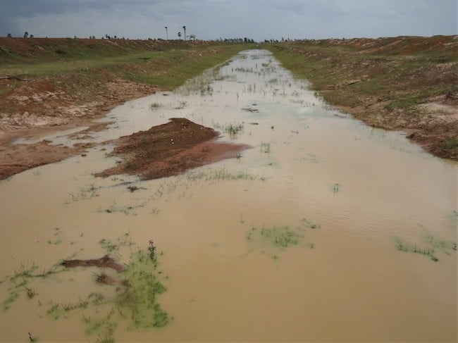
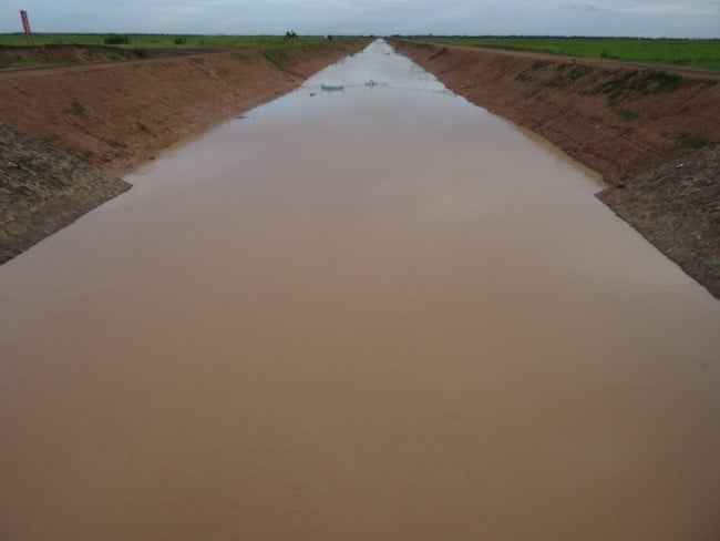
To get a sense of the scale and scope of this project, I travelled by motorbike for two days along an interlinked network of irrigation canals (see photos 1 and 2), starting in Me Sang district of Prey Veng province, navigating my way northwards via Kamchay Mea and Sithor Kandal districts towards the project headworks at Beung Kapik lake in Koh Southin district of Kampong Cham province. Altogether, I drove along 73 kilometres of canal, of which at least 40 kilometres are believed to have been funded by the Chinese aid project and are immediately recognisable due to their mammoth dimensions (clearly visible from satellite images), that dwarf anything built before in this flat landscape, including the deadly Khmer Rouge canals of the 1976-79 period.
Some of the canals we followed dated from pre-2010 and were no doubt paid for by different donor bodies, though which nation or project funded them was hard to tell, as there was a puzzling lack of donor logos and signage along the entire route. Normally, donors (and government agencies) are keen to advertise their generosity, often with prominent signs in Khmer and English, but this was not the case in Prey Veng where funders seemed to be laying low and unaccountable, despite (or because of?) the size of the funds involved in digging the canals. Consequently, most villagers spoken to were unaware of the source of funding for the local canals or whether it involved a grant, a loan or was paid for directly out of state-raised funds. Elsewhere, I have heard people point to a canal and say it is “Hun Sen’s canal” (or “Pol Pot’s canal for some older ones). Powerful personalities matter and canals are iconic symbols of their rule.
Infrastructural disintegration and disrepair – and no irrigation provision
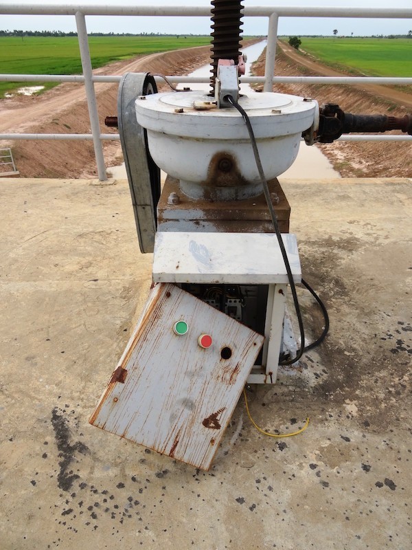
Several observations stood out as I tracked the canal banks across the monotonous Prey Veng landscape (albeit greener than on my last visit) occasionally stopping to talk with farmers and other potential water users or managers. Firstly, I noticed that the older canals and parallel roads (i.e. pre-2013 start of the Chinese funded project) were in an appalling state of disrepair, with long sections impassable to any other vehicle than a motorbike or bicycle and even then it proved hard going for mile after mile, as no maintenance of either canal nor road was in evidence. The laterite track resembled an all-terrain mountain bike course, the earthen canal banks pitted and crumbling on both sides, and occasional concrete drainage pipes cracked and exposed, utterly useless. Virtually every watergate structure encountered was broken, rusty, non-maintained and inoperable. Along the Chinese built sections, while the roads were in better condition because they were newer, there was already serious bank erosion evident and the sluice gates appeared largely inoperable, often because the lifting motors were broken or vandalized.
Most surprisingly, along the entire 73 km stretch surveyed not a single field was being irrigated by gravity from the canals, as the water level of the canals was well below that of adjacent fields resulting in the main canal acting as a glorified drainage ditch, rather than a water supply channel. In the few places where secondary lateral canals had been dug at right angles to the main canal, again these were acting as drains from the paddy fields into the main canal, which was presumably not the original intention, but that they would act as water supply channels. This remained a rainfed landscape, not an irrigated one. It was once said in the context of the American West that water tends to “flow uphill toward money and power”, but it obeys gravity otherwise, and this project seems to be similarly hydrologically illiterate while cognate to the laws of unchecked power.
Even though July was supposedly the rainy season, it was striking how little water lay in the main canals, which resembled little more than long muddy puddles unable to reliably store or transport water to fields. There was hardly any more water in them than I had seen in the dry season. One wondered if this “drought” was perhaps due to the inability of the designers to figure out the actual hydrology and topography of the terrain or merely poor construction quality compounding design flaws in a water-landscape ill-suited to irrigation in the first instance.
Hence, the vast majority of farmers – even those with land right next to the main canals – were relying on mother nature to water their rice crops, as has been the case for generations past. Only a handful were using small tractor pumps to raise the muddy water from the main canals to their paddy fields via plastic pipes laid over the road. Many fields even right next to the canals were showing signs of drought stress. The fact that so few were investing in pumps, suggested it was an economically questionable proposition, given the present cost of fuel, the unfertile and porous soils notoriously bad for holding water that are renowned for producing low average rice yields in this area of eastern Cambodia.
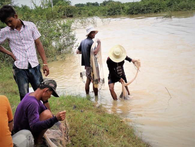
Thirdly, farmers we met alongside the route explained that rice cultivation was an inherently risky and low yielding activity on these soils. While a secure and cheap water supply was desirable, the oversized and largely empty canal had done nothing to help them so far. Indeed, for some it had proven a blockage to the natural flow of water across the landscape, leading to local waterlogging and flooding following heavy rain and drought at other times of year, where the canal acted as a hydrological obstruction. At one point, it was possible to see that a natural watercourse had been interrupted by the canal and such structures inevitably impede or disrupt the movement of native fish and aquatic wildlife across the floodplain. The muddy canal full of suspended sediment had become a productive fishery in itself, due to its sterile and featureless characteristics.
However, the mere presence of the vast canals acting as avatars of an official irrigation scheme and though state agency encouragement, many farmers living in its shadow seemed to have been incentivized to attempt double cropping of rice, though they were obliged to access water from sources other than the canals in most instances. The simple reality is that without a steady supply of water in the canals and no means of reliably distributing it to the fields, then most farmers are bound to either pump groundwater, small surface water sources like ponds or swamps or wait for capricious rain gods to irrigate their crops.
State officials wearing many hats
In terms of water management, the absence of a reliable water supply and functioning distribution system from the main canal to fields (only a handful of secondary canals have been constructed, and no tertiary or quaternary canals were observed), means that unlike some other donor-assisted schemes in Cambodia there are no credible state-water user management institutions, usually referred to as Farmer Water User Communities (or FWUCs). Furthermore, the lack of a functioning irrigation system seemed to explain a similar scarcity of government officials on the ground, including the agency that has nominally benefitted most from the Vaico River scheme and is ultimately responsible for its management – the Ministry of Water Resources and Meteorology (MoWRAM). Whether MoWRAM views its task as purely one of meta planning, fund oversight and directing project construction up to the point of completion can only be speculated upon, but it is a common observation in Cambodia that state officials seem to disappear from the scene once a project is complete, leaving local farmers and commune authorities to live with the consequences of poorly planned, largely unaccountable and opaque decision-making that characterizes such developments.
The one and only MoWRAM official we came across along the entire journey was a deputy village head in Doun Koeng Commune, upstream of Kamchay Mea District, not far from a low head concrete dam straddling the Vaico River. He told us he was responsible for maintaining about 7 kms of canal and held the sluice key for the watergate nearest his house, allowing him to open or close the sluice if required. To his credit, this was the one and only sluice that seemed oiled and maintained along the whole length surveyed. He said the main canal by the village was built in 2009, before the Chinese-funded Vaico River Project started, but is hydrologically connected to it less than 500 m upstream at a spot marking its lower limits. The Chinese scheme consists of two branches built around 2015 – one canal running roughly east-west towards Svay Antor district and the other running on a northwest axis towards Sithor Kandal district.
In the village sits a FWUC office and meeting hall built in 2010, but the FWUC apparently folded within three months of formation, as members unsurprisingly refused to pay water fees in the absence of a functioning water supply. He admitted that an original plan to channel water by gravity from the hills of Kampong Cham province down to this point had not succeeded and a later plan to pump water into the canal had been rejected, as it was deemed too expensive. There are some 230 households in the village of which 90 practice dry season rice cultivation, but only 20 households have access to the canal water, which has to be pumped and is never enough to meet needs. Hence, the canal runs dry easily and most families are obliged to use groundwater to irrigate their crop, which he says is better quality than the canal water. Typical yields are 3 tonnes per hectare for wet season cropping and 3 – 4 tonnes per hectare for dry season cropping, dependent on intensive inputs. Interestingly, he told us that after several farmers died from misuse of pesticides, many local people have become scared to eat fish, frogs, crabs and other aquatic animals from the paddies, as they believe they are contaminated by chemicals. These animals have become much scarcer in recent years with the rise of double cropping, so villagers have to rely more on purchased foods than before. Out-migration is a serious local issue, especially of younger people, making finding agricultural labour problematic.
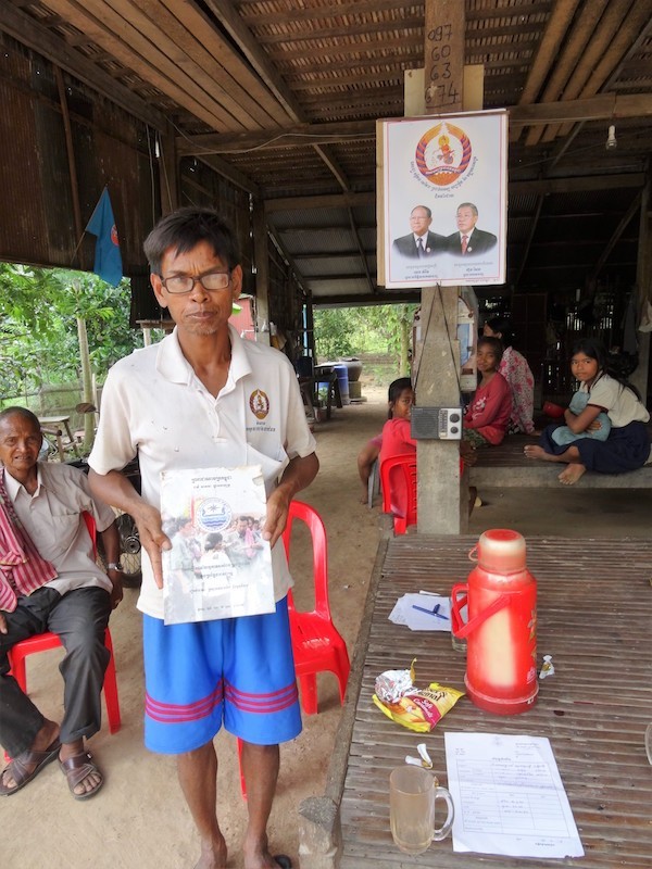
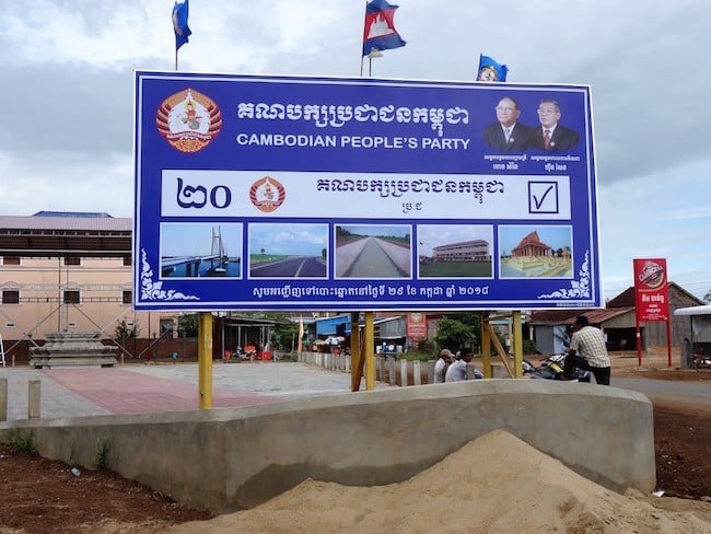
In addition to his twin roles as village deputy head and a MoWRAM official (to fulfill his position he is required to travel once a month to the provincial capital to attend a meeting and collect his salary), the informant also acted as a local Cambodian People’s Party (CPP) representative. This latter function seemed to be the main priority at the time of my visit, with the general election looming in less than two weeks. Sporting a CPP logo emblazoned shirt he embodied the inextricable links that now exists between the ruling party, the central bureaucracy and local officials across the country. As observed in Takeo Province with the CAVAC irrigation project at Wat Thmey, irrigation schemes have become politics and power-saturated arenas, largely controlled by the CPP hierarchy.
Meanwhile, Western bilateral and multilateral donors seem reluctant to recognize the reality but continue to financially underwrite the CPP’s ascendency. Hun Sen’s political network now controls the nation’s hydraulic infrastructure in a far more complete and insidious manner than the unstable Khmer Rouge which relied only on Mao’s China for financial and technical support. Hun Sen, by contrast to Pol Pot, can call on the compliance of a dozen or more donors quite willing to help propagate the advance of his network and interests. As cogently argued by Sophal Ear, in cases like Cambodia, such aid dependence frequently undermines democracy and encourages bad governance.
Growing headworks, growing hydraulic influence
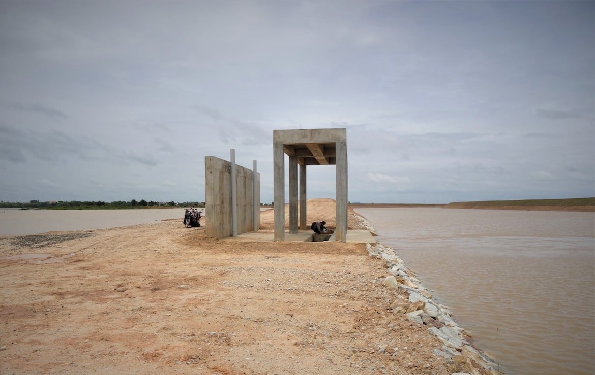
Up at the head of the main Chinese canal project lies Beung Kapik, a large lake and wetland system that is hydrologically connected to the Mekong mainstream and has long nurtured local livelihoods through a rich provision of fish and numerous other aquatic plants and animals. In addition, it patently fulfills myriad ecosystem services for the local area, not least as a communal source of water for agriculture and domestic consumption in its own right, a fact that seems to be lost on the Chinese developers working hand in glove with MoWRAM to “develop” it as a headpond for the Vaico River scheme. Since I was last there in February 2017, further civil works have taken place at the outlet on the southern side of the lake. The banked canal that juts obtrusively into the lake has been extended outwards into the shallow lake, splitting it into two sections. A concrete structure has been partly built that appears to act as some kind of outlet sluice and a large “control” building is in the early stages of construction at the main canal fork to the south of Beung Kapik. As the canal exits the lake, some of the banks have been planted with grass in an attempt to stop erosion, but it seems unlikely that this effort will work without regular care and maintenance, an element that seems to be singularly lacking throughout this project.
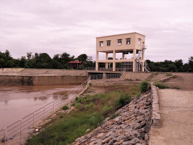
On the opposite side of the lake near Koh Soutin township, the project has constructed a large electrically-operated double watergate structure, that presumably was designed to allow water in to Beung Kapik during the flood season and then hold it during the dry season so it can be diverted to the massive Vaico River Project via means of gravity. The only trouble is the idea has failed to materialise, as presumably the planners did not adequately comprehend and design for the complex hydrological nature of Beung Kapik and local topography. Perhaps they missed the fact that Beung Kapik also overflows on its southern fringe and distributes water across a large area of floodplain in Sithor Kandal district, naturally irrigating and fertilising with suspended nutrients tens of thousands of hectares of land, thus creating an expansive seasonal wetland beyond the confines of the lake. The watergates essentially do not function as intended while the main canal outlet fails to capture sufficient water due to serious miscalculation and in any case, it is doubtful there is sufficient water held in the shallow Beung Kapik to irrigate the vast area envisaged in Prey Veng province without draining it dry.
On the day I visited, a curious hydrological event was underway mirroring on a smaller scale the far more famous phenomenon associated with the Tonle Sap river and lake. With plenty of rain upstream, the Mekong river level had risen to the point where it was over-spilling through channels between the mainstream and marginal lakes and swamp depressions behind the levee. This annual overspill functions as a natural “release valve” mechanism for the Mekong mainstream and relieves areas further downstream in the Delta from more catastrophic flooding, while helping fish and other aquatic animals to complete their lifecycles and feed in habitats that are diverse in food and spawning places, such as Beung Kapik. It is an integral part of the so-called “flood pulse” concept of tropical lowland rivers like the Mekong, adding to its productivity. Yet the Chinese-funded irrigation scheme threatens to destroy much of this critical wetland habitat and the eco-hydrological event on which it depends.
Compounding conceptual flaws in the system
The senior MoWRAM hydraulic mandarins responsible alongside their Chinese counterparts either seem to have not realized the litany of design mistakes or ignored them, perhaps safe in the knowledge that there has been no external scrutiny of the scheme and thus allowed to proceed unchecked to this point. But rather than own up to the Cambodian nation about this spectacular development failure and order an investigation as to what went wrong, who should be held responsible and what would be an appropriate future course of action to rectify the damage, the government seems intent on compounding the problem further by expanding the scheme. The project is evidently not being wound up, as would be the prudent thing to do, but is actually entering a new phase. This was indicated by local reports at the existing redundant outlet in Koh Soutin that a Chinese construction company had bought 30 nearby houses at a cost of US$10,000 – US$25,000 per property through a compulsory purchase order and was planning on building a larger dam structure.
It seems this new phase intends to enlarge the existing project by diverting (or pumping?) more water from the river forming the border of Kampong Cham and Prey Veng provinces into Beung Kapik via the partially-completed mega canal, thereby channeling it to the existing lake outlet on the southern edge. Indeed, a contact in Phnom Penh told me that this new phase would cost $300 million, eventually leaving the Cambodian people with a half a billion dollars total debt to repay to China, yet with no guarantee that the new phase will be any more successful than the first. One thing that can be assured, however, is that the social and environmental costs of the expanded scheme will be immense, especially for the many households currently living around Beung Kapik who stand to have their livelihoods ruined, with no compensation.
Little or nothing seems to have been learned by the sector since almost identical criticisms were made of similar systemic irrigation development failures back in the mid-1990s, when development aid money began to flood in to fund new irrigation schemes and rehabilitate a number of Khmer Rouge schemes that had fallen into disuse, but with exceedingly poor results. In 2008, a well-known domestic NGO conducted a nationwide assessment of over 2,500 irrigation projects and found that the vast majority were considered either “partly functional” (34%) or “non-functional” (59%). It is unlikely that these figures have improved much since. The inability of the irrigation industry in Cambodia to learn past lessons and endlessly replicate failures, is uncanny, if not disturbing.
Periodic sectoral reviews made by donor-hired consultants offer little confidence that the basic lessons are being internalized by an irrigation industry always on the hunt for new projects to implement along old paradigms, as suggested by a 2017 “Strategic Framework for the Irrigation Sector” prepared by The World Bank Group. The consultants, it seems, are reluctant to get out into the field and empirically connect with a landscape of patent failure. Such reports are nearly entirely based on faulty assumptions, while essentially repeating prescriptive recommendations that have not worked in the past.
As China expands its presence in Cambodia, it is systematically creating a satellite hydraulic society , albeit built on a record of hydraulic mismanagement and failure. In the absence of the rule of law, minimal standards of social justice and stakeholder participation in decision-making processes and a lack of transparency or accountability by state institutions, Cambodia’s toxic atmosphere of one party and one-man rule now more closely resembles Wittfogel’s characterization of a hydraulic society than at any point since the Angkor era, when hydraulic development was geographically confined and technologically limited. Human labour has been replaced with vast machines that complete hydraulic infrastructure projects in a fraction of the time, but still come at a considerable cost to the environment and society, in the short and long term.
Following the landslide victory of Hun Sen on July 29, one wonders whether there is any actor or institution left to challenge the warped logic and woeful execution of such projects hidden in plain sight of influential “development partners”. On top of the failure shown to date, the expanded Vaico scheme could easily compound problems downstream, if it is allowed to pump or divert water from the Mekong mainstream. Such a pathway could ultimately negatively impact Vietnam as well, given that the Vaico river disgorges into the South China Sea south of Ho Chi Minh city. A case for the presently supine MRC perhaps?
David Blake has worked and conducted research on environment and natural resources management issues across the Lower Mekong Basin countries for over 20 years. He has a PhD from the School of International Development at the University of East Anglia on the political ecology of irrigation development in Northeast Thailand.


